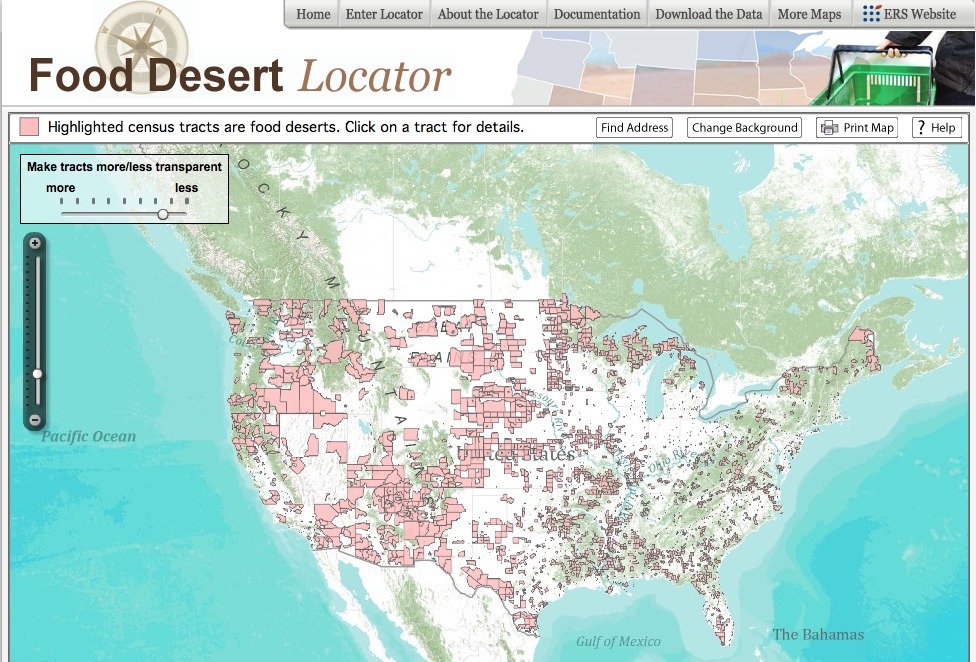
Following on previous efforts to make information available to the public using visual interfaces, USDA’s Economic Research Service (ERS) released the Food Desert Locator this week. This new tool provides population characteristics of areas considered food deserts according the definition by the Healthy Food Financing Initiative (HFFI) Working Group.
The HFFI, a partnership between the Treasury Department, Health and Human Services, and the Agriculture Department (USDA), with the collaboration of ERS staff, defines a food desert as a low-income census tract where a substantial number or share of residents has low access to a supermarket or large grocery store. To qualify as a food desert tract, at least 33 percent of the tract’s population or a minimum of 500 people in the tract must have low access to a supermarket or large grocery store.
This definition will be used to determining eligibility for HFFI funds, with the purpose of expanding the availability of nutritious food by developing and equipping grocery stores, small retailers, corner stores, and farmers markets with fresh and healthy food. This project is part of a larger strategy supported by the First Lady’s Let’s Move! Initiative.
According to the HFFI Working Group, 6,500 census tracts in the continental U.S. meet the definition of a food desert (food deserts are not yet defined for Alaska and Hawaii); roughly 75 percent of which are urban and have an impact on 13.5 million people.
What can you do with the food desert locator?
• Locate and visualize a spatial overview of where food-desert census tracts are located;
• Access selected population characteristics of food-desert census tracts; and
• Download data on food-desert census tracts for community planning or research purposes.
When the user enters the Locator, he/she will see food deserts distribution in the US (from the national until census tract units) highligted.
The Find Address button allows zooming in as close as to display census tracts.
Once the user identifies a location to explore further, s/he can click and a window with all population characteristics of the location will pop up. Printing a map or downloading the data is also allowed.
This user-friendly tool compiles data on population and income from the 2000 Census of Population and Housing; the Socioeconomic Data and Applications Center; information on supermarket and large grocery store locations from a list of stores authorized to receive Supplemental Nutrition Assistance Program (SNAP) benefits, augmented by data from Trade Dimensions TDLinx. Details on these data sources can be found in the 2009 ERS report, Access to Affordable and Nutritious Food: Measuring and Understanding Food Deserts and Their Consequences.
Access the Food Desert Locator here.


